Introduction
What is a Neighbourhood Plan, and why is this needed in Swanage?
A Neighbourhood Plan is a community-led planning document that gives local people a direct say in how their area should evolve. Its purpose is to deliver a Plan containing policies to protect the character of the town and ensure that future development delivers benefits for local residents. Through this mechanism, the community can influence where and how development happens, supporting opportunities for community-led housing, safeguarding green spaces, allotments, and important community facilities, and protecting valued character areas. Prepared in line with local and national planning policy and approved through a local referendum, the Neighbourhood Plan sets out a shared vision to guide growth in a way that strengthens and enhances the neighbourhood for generations to come.
Having an adopted Neighbourhood Plan also means that the community receives a larger share of the Community Infrastructure Levy (CIL) from chargeable developments. The share increases from 15% (for communities without a Plan) to 25% once a Plan is in place.
Who is leading the preparation of the Swanage Neighbourhood Plan?
The preparation of the Swanage Neighbourhood Plan is being led by the Swanage Neighbourhood Plan Steering Group. This is a sub-committee of the Town Council’s Planning and Consultation Committee. The Steering Group comprises six town councillors and up to six community representatives with relevant skills and experience. Currently the Steering Group’s community representatives include members of Sustainable Swanage, Planet Purbeck, the Purbeck Society, and the Swanage Community Housing Group.
During its research, the Steering Group commissioned various reports to inform the creation of the draft Pre-submission Plan, including a Housing Needs Assessment, Strategic Environmental Assessment, and a Habitats Regulations Assessment. To support this work the Group was successful in securing free technical assistance and grant funding of £5,780 from Locality (the main support body funded by the UK government to help communities create Neighbourhood Plans). Copies of agendas and minutes of the Steering Group’s meetings can currently be found here:
1. Introduction
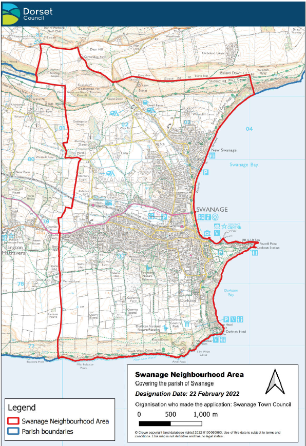
- Swanage Town Council is preparing the Swanage Neighbourhood Plan to cover the period 2026 – 2043. The ‘neighbourhood area’ was designated by Dorset Council, the local planning authority, for this purpose in February 2022 and coincides with the parish boundary (see Plan A below). The Town Council is a ‘qualifying body’ to bring forward the Plan in accordance with the Neighbourhood Planning (General) Regulations 2012 (as amended).
- Once ‘made’ by Dorset Council, the Plan will become part of the ‘development plan’ for Swanage and, alongside other development plan policies (at the Purbeck and Dorset levels), its policies will be used to determine planning applications in the designated area. It also establishes the priorities for investing in local infrastructure improvement.
- The Plan has reached the stage of its formal consultation, following more than two years of the Town Council’s project steering group gathering and analysing planning data. Extensive engagement with the community has been carried out, with surveys and in-person drop in events organised by Dorset Coast Forum in partnership with the steering group (September-November 2025). The results can be found at Dorset Coast Have Your Say and were important to inform the objectives and policies of this plan. Dorset Council and other local stakeholders were also consulted over the period that this plan was put together. The evidence reviewed in particular includes the Housing Needs Assessment of March 2024 and the Swanage Seafront Masterplan of 2025 but also a number of the relevant technical reports published by Dorset Council for the adopted Purbeck Local Plan and for its emerging Dorset Local Plan.
- The group will review the comments made on this version of the Plan and make modifications to a final version, which will be submitted by the Town Council to Dorset Council in spring 2026. Dorset Council will then arrange the independent examination of the Plan before a referendum is held later this year. If a majority of the turnout of those on the Swanage electoral register vote in favour of the Plan, then it will immediately carry its full status before Dorset Council formally makes the Plan.
- The Plan’s objectives and policies have been subject to a Strategic Environmental Assessment and will be screened for a Habitats Regulation Assessment before it is submitted. The recommendations of both will be incorporated into the final version.
2. Background
Brief History
- The settlement of Swanage has evolved significantly from its early days as a largely agricultural settlement, its Saxon name of Swanawic most likely meaning the dairy farm of the herdsmen. Like many modern coastal parishes in Dorset it was a secondary settlement, it being dependent on its mother parish of nearby Worth Matravers.
- For much of its history Swanage consisted of a string of settlements around the quayside and along the line of today’s High Street from the Quay towards the parish church, then again at Court Hill, Newton and Herston, with Ulwell to the north. By the eighteenth-century Swanage was an industrial township, with quarries of Purbeck stone across the southern hillside. The stone was conveyed by horse and cart to stone yards, known as bankers, along the shoreline, before being transferred to boats in the bay for shipment.
- The modern town emerged from the mid-nineteenth century onwards as it developed a reputation as a health resort. However, initial development in the 1820s/30s (lower High Street/Seymer Road) and 1860s/70s (Park Road and Grosvenor Road) proved to be limited in scale. The population of Swanage only overtook that of Corfe Castle in the 1840s and that of Wareham in the last quarter of the nineteenth century.
- The most significant change was brought by the arrival of the railway in 1885. Firstly, this enabled the stone bankers to be cleared from the seafront and transferred to the station yard, leaving the seafront free for redevelopment. As more visitors arrived the modern town centre expanded northwards from the old High Street with the creation of Institute Road and Station Road, which was partly built over the brook. Seafront infrastructure was constructed in the first quarter of the twentieth century with the building of a sea wall and seafront shelters, the laying out of public gardens, beach huts and a bandstand, and the widening of Shore Road.
- From the late nineteenth century the modern town started to take shape, with expansion southwards towards Durlston, and northwards from the station with the laying out of Victoria Avenue and new roads on the De Moulham estate. The years around 1900 saw Swanage gain its first suburb unconnected with the old town, known as ‘New Swanage’, centred on Ulwell Road and Burlington Road. By 1921 Swanage was one of the biggest market and coastal towns in Dorset, behind only Poole, Weymouth & Portland and Dorchester.
- Growth continued both between the world wars and in the years after 1945, including the construction of large numbers of council houses at Herston providing spacious family homes for working families. From the 1960s the construction of private housing moved away from local builders providing bespoke houses on individual plots, which provides the town with much of its character, towards larger estate development on greenfield sites at D’Urberville Drive, Cauldron Barn and at Benlease.
- Swanage was struggling by the mid-1970s, following the loss of secondary education with the closure of the Grammar School, the closure of the railway line in 1972 and the loss of its urban district status in 1974. Paddle steamers stopped calling and the Pier became dilapidated and closed to the public. As foreign holidays grew in popularity many hotels shut down, the Grosvenor and Corrie being demolished and remaining as building sites for many years in the late 1980s and early 1990s.
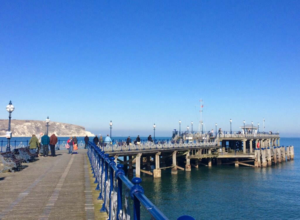
- The last 30 years has seen a strong revival in the town’s fortunes. The mid-1990s saw the construction of a flood defence scheme that has prevented recurrence of the serious flooding which previously afflicted the town centre; the laying out of new public greenspace at Prince Albert Gardens; the re-opening of the Pier; and the construction of a new town centre supermarket. The first quarter of the twenty-first century has seen the reconnection of the railway with the mainline at Wareham, the construction of a new industrial estate, and the return of secondary education to 16 with the opening of the Swanage School. A broader-based tourist economy has developed, focused on the great outdoors, boosted by the presence of Durlston Country Park, now designated as a National Nature Reserve, and the town’s role as the eastern gateway to the World Heritage Jurassic Coast.
- 2.5 In terms of development, there was a hiatus in housebuilding following the construction of Marsh Way and Ash Close at Herston in the early 2000s. For the next two decades development focused on the demolition of large family homes and hotels and their replacement with flats, many of which became second homes. Although the number of dwellings increased, the number of residents declined between the censuses of 2001 and 2011. Only since 2020 has there been a significant increase in the number of family homes with the development of the Compass Point estate off of Northbrook Road, on sites allocated in the Swanage Local Plan of 2017.
- It should be remembered that the Swanage that we see today is as much the product of development that didn’t take place as that which did. The preservation by the local authority of public greenspace along Shore Road and at Peveril Point (recently designated as a Local Nature Reserve) on land which had been earmarked for development by private landowners in the past, continues to make a significant contribution to the character of the town. Had the proposal for a marina gone ahead as planned in the late 1980s this would also have had a significant impact on the character of the town.
- The Swanage Neighbourhood Plan seeks to establish policies that will guide the future development of the town in a sustainable manner, preserving our natural habitat and what is best from past generations, whilst ensuring that new development can provide quality housing for future generations of local residents, thereby ensuring that the town can continue to support a vibrant community.
Profile
Overview
- Swanage is a traditional seaside town at the terminus of the A351 on the south-east coast of Purbeck. Surrounded by the sea on two sides and connected to the wider area by a single main road, the town’s growth and development have been naturally constrained. It is the largest settlement in the area and provides a broad range of services, community facilities, and tourist attractions. The main railway line divides the town into North and South Swanage. Herston, once a separate settlement, retains a distinct village character and forms one of two conservation areas.
Population
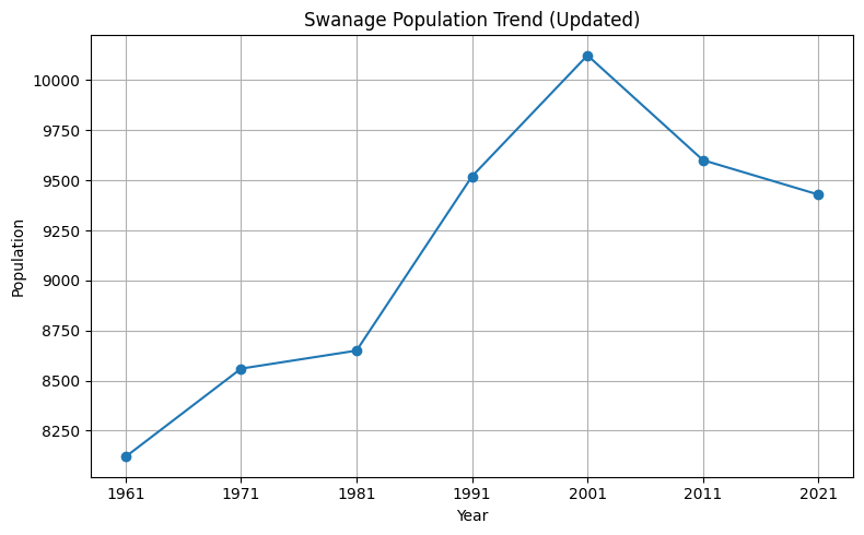
- Swanage has a resident population of approximately 9,400 (Office for National Statistics (ONS) mid-year estimates in 2024 9,411) reflecting a gradual decline since 2001. As a major visitor destination, population levels rise significantly during the holiday season, with around 116,700 staying visitor trips per year, and 786,900 day visits. (The South West Research Company, Swanage Tourism Summary 2024-modelled data)
- The town has an older demographic profile, with 37.4% (ONS mid-year estimates 2024) of residents aged 65+, higher than both the Dorset Council area (30.5%) and England and Wales (18.9%). The proportion of young people is correspondingly lower than the national average.
Housing
- Housing affordability is a significant issue in the area. Around 20% of the housing stock consists of second or holiday home properties, compared with 3% across Dorset, with Swanage having one of the highest concentrations of registered second homes within the Dorset Council area (ONS October 2023 11%, compared with 1.6% across Dorset). The 5-year average price-to-earnings ratio in the area is 11.06 (ONS), which is significantly above the national average of 8.21 for England and Wales.
- The 5-year median property price is approximately £333,500, while median full-time annual earnings over the same period are approximately £30,200 (ONS). Certain parts of Swanage have experienced extreme price growth (reaching up to 33.5% in a single year). Although house price growth is slowing nationally, the Swanage and wider Purbeck area continue to exhibit strong housing demand, reflecting their status as desirable coastal markets.
Community Facilities and Services
- Swanage has a wide range of community services including:
- Three primary schools and one secondary school with a full-size sports hall.
- A medical centre, hospital, dental services, and pharmacies.
- Churches, community halls, sports clubs, and leisure facilities.
- A library, museum, theatre, information centre, and town hall.
- A good selection of shops, cafés, restaurants, and pubs.
- Swanage has a strong community spirit and strives to remain independent, with many local groups, services, and initiatives supporting residents helping the town remain resilient despite its remote coastal location.
- Education has transitioned from a three-tier to a two-tier system, with new or relocated primary schools, and the opening of The Swanage School. Future pressure may create a need for sixth-form provision.
Built Environment
- Swanage developed from an agricultural and quarrying community into a Victorian seaside resort. This history is reflected in its urban form and varied architecture, including notable late 19th-century buildings such as the Town Hall and Purbeck House. Housing includes substantial inter-war and post-war development.
- Two conservation areas, Herston and the historic town centre/Peveril Point, contain the town’s most significant heritage assets. Swan Brook runs through the town via a culvert beneath Station Road.
Natural Environment
- The town sits entirely within the Dorset National Landscape and is surrounded by nationally recognised landscapes, including Durlston Country Park (partly a National Nature Reserve), Townsend Nature Reserve, Ballard Down, and Peveril Point and The Downs Local Nature Reserve.
- Although not directly adjacent to heathland, Swanage lies within 5 km of Studland and Godlingston Heaths, requiring mitigation for new development.
- Swanage Bay stretches from Peveril Point to Handfast Point and is partially sheltered from major storms, though easterly gales present a flood and erosion risk. The coastline is subject to several designations, including the Jurassic Coast World Heritage Site, Special Area of Conservation, Special Site of Scientific Interest, and Heritage Coast. The seafront includes the pier, promenade, beaches, and a variety of water-based and recreational attractions.
Economic Characteristics
Town Centre and Retail
- Swanage has the largest and most diverse town centre in Purbeck, valued for its independent shops, cafés, restaurants and services. Two supermarkets serve the town centre. The retail area focuses on Station Road, Institute Road and the High Street. There is no central public square suitable for markets or large events.
Employment & Tourism
- The local economy is mixed, with strong representation in tourism, public services, retail and light industry. Major employers include Swanage Town Council and other local authorities, the NHS, and Ibstock Bricks. Seasonal variation remains a feature of the economy. Tourism plays a particularly important role, supporting a significant proportion of local employment. However, the town experiences a net loss of working residents due to out-commuting, highlighting the need to strengthen local employment opportunities.
- Tourism is a major economic driver, supported by the beach, pier, promenade, Swanage Railway, and outdoor recreation. Annual tourism indicators include: 116,700 staying visitor trips; 786,900 day visits; 528,100 total staying nights; £35.9m day visit spend; £68.4m total direct spend; £76.1m total visitor-related spend; and around 885 jobs supported (The South West Research Company, Swanage Tourism Summary 2024-modelled data).
Accessibility and Transport
- Transport connections rely heavily on the A351 and the Sandbanks chain ferry, both of which experience significant peak-season congestion. Public transport links provide access to Poole, Bournemouth and Wareham, though services are under funding pressure.
- Swanage Railway’s ongoing proposal for the Swanage–Wareham rail reconnection may enhance sustainable travel options. Future improvements are guided by the Purbeck Transport Strategy, which identifies several relevant improvements, including enhanced bus services and upgrades to pedestrian and cycling routes.
- Overall, Swanage’s distinctive coastal setting, heritage assets, strong visitor economy and wide range of services underpin its role as an important settlement in Purbeck, while its ageing demographic, housing pressures and seasonal congestion present ongoing challenges for the Neighbourhood Plan to address.
Strategic Planning Policy
- The development plan covering Swanage comprises the Purbeck Local Plan (PLP) 2018-2034 adopted in 2024; the Swanage Local Plan (SLP) 2017-2027 adopted in 2017; the Bournemouth, Christchurch, Poole and Dorset Waste Plan adopted in 2019; and the Bournemouth, Dorset and Poole Minerals Strategy reviewed in 2020.
- The PLP provides an up-to-date strategic policy framework for this Plan. Swanage is the largest of the three towns in the former district and a number of its policies are especially relevant:
- V1/H2: Spatial strategy for sustainable communities – providing for approx. 91 homes in Swanage
- E1: Landscape – restating the importance of the Dorset National Landscape
- E2: Historic Environment – restating the importance of designated and other heritage assets (e.g. the town’s Conservation Areas and Listed Buildings)
- E6: Coastal change management areas – identifying the town as a CCMA for managing future development
- E7/E8/E9: Conservation of protected sites – identifying the town as being affected by a number of surrounding international habitats, including the Dorset Heathlands and Poole Harbour
- E12: Design – encouraging Neighbourhood Plans to provide the basis for locally distinctive design policies
- H8: Small sites next to existing settlements – allowing for housing schemes up to 30 homes on land adjoining a town Settlement Boundary but not if a neighbourhood plan has made its own provision to meet identified housing needs
- H9: Housing mix – encouraging neighbourhood plans to use local evidence to support local mix policies and encouraging schemes of more than 20 homes to provide 5% as self-build plots and 10% as bungalows
- H11: Affordable housing – requiring housing schemes to deliver between 20% and 40% as affordable homes on site, depending on their location, with a specific tenure mix
- H14: Second homes – requiring new housing in the town to have a restriction in perpetuity to ensure that such homes are occupied only as a principal residence
- EE1: Employment land supply – safeguarding the Prospect Business Park and Victoria Avenue Estate employment sites in the town
- EE3: Vibrant town and local centres – identifying Swanage town centre at the top of its hierarchy of centres
- I4: Recreation, sport and open space – including safeguarding existing facilities
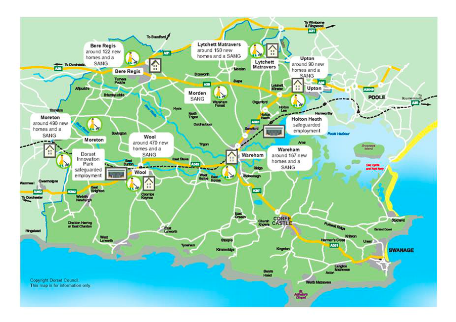
- The emerging Dorset Local Plan (eDLP) will replace the PLP and cover the plan period to 2043. It is at an early stage in its preparation but is expected to be submitted for examination by the end of 2026. It will not have been adopted by the time of the examination of this Plan but its evidence and reasoning, as set out in the most recent consultation version of August 2025, is being taken into account.
- The Swanage Local Plan (SLP) is a statutory planning document that currently sets out the vision, strategy, and land-use policies for the town of Swanage over the period 2017–2027. It was prepared in partnership by the former Purbeck District Council, Swanage Town Council, and the Swanage Town and Community Partnership, and through extensive community engagement, being formally adopted by Purbeck District Council in June 2017.
- The SLP provides locally specific planning guidance to supplement the wider strategic policies of the Purbeck Local Plan 2018-2034 (PLP), which was adopted in 2024. The SLP contains ten policies covering topics such as housing, town centre development, employment land, green infrastructure, and open space. As the Swanage Neighbourhood Plan (SNP) and Purbeck Local Plan now provide updated or superseding policy coverage in several of these areas, the SNP sets out how each SLP policy is proposed to be carried forward, replaced, or allowed to expire. See table below.
- Further information on the SLP and PLP can be found here:
| SLP Policy | SLP Policy Title | Status with SNP and/or PLP |
|---|---|---|
| SS | Swanage Settlement | Replaced by SWAN1, SWAN2, SWAN3, SWAN 6, SWAN9 and SWAN10 |
| SHM | Swanage Housing Mix | Replaced by SWAN3 and PLP Policy H9 |
| STCD | Swanage Townscape Character and Development | Replaced by SWAN6 |
| STC | Swanage Town Centre | Replaced by SWAN5 |
| TCR | Town Centre Redevelopment | Not replaced – will expire in March 2027 |
| KCD | Kings Court Depot Site | Replaced by SWAN2 |
| ES | Employment Sites | Superseded by PLP Policy EE1 |
| SGI | Swanage Green Infrastructure | Part replaced by SWAN7 and superseded by PLP Policy I3 |
| OSR | Open space and recreation | Replaced by SWAN7 |
| SA | Swanage Allotments | Part replaced by SWAN7 and superseded by national policy and PLP policies I4 and I7 |
National Planning Policy
- The Plan has also had regard for national planning policy and guidance as set out in the current 2024 version of the National Planning Policy Framework (NPPF). Its most relevant policies for Swanage are:
- §61 – emphasises that to support the Government’s objective of significantly boosting the supply of homes, it is important that a sufficient amount and variety of land can come forward where it is needed
- §98 – planning should also guard against the unnecessary loss of valued facilities and services, particularly where this would reduce the community’s ability to meet its day-to-day needs and should ensure that established shops, facilities and services are able to develop and modernise, and are retained for the benefit of the community
- §103 – access to a network of high-quality open spaces and opportunities for sport and physical activity is important for the health and well-being of communities, and can deliver wider benefits for nature and support efforts to address climate change
- §106 – the designation of land as Local Green Space through local and neighbourhood plans allows communities to identify and protect green areas of particular importance to them
- §124 – notes that planning policies and decisions should promote an effective use of land in meeting the need for homes and other uses, while safeguarding and improving the environment and ensuring safe and healthy living conditions.
- §189 – states that great weight should be given to conserving and enhancing landscape and scenic beauty in National Landscapes which have the highest status of protection
- §192 – states that to protect and enhance biodiversity geodiversity, plans should safeguard components of local wildlife-rich habitats and wider ecological networks, including the hierarchy of international, national and locally designated sites of importance for biodiversity
- §202 – states that heritage assets are an irreplaceable resource and should be conserved in a manner appropriate to their significance, so that they can be enjoyed for their contribution to the quality of life of existing and future generations.
- In December 2025 the Government published for consultation a significant redraft of the NPPF, which will require neighbourhood plans like this one to be examined against its policies once finalised. This new NPPF will be in place before the Plan is submitted, so the policies have been drafted to reflect the structure and content of the proposed National Decision-Making Policies (NDMP).